Monday, June 30, 2008
Pump Station 10
Sunday, June 29, 2008
Geophysical Institute
Denali Fault Crossing
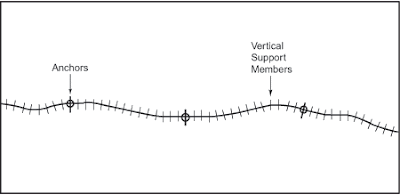
Vertical Support Member Diagram
Buried TAPS Pipeline Diagram
Tuesday, June 24, 2008
Zig Zag Diagram
Monday, June 23, 2008
Introduction: The Trans Alaska Pipeline System (TAPS)
Summary: The Trans Alaska Pipeline was designed and constructed to move oil from the North Slope of Alaska (Mile Post 800) to Valdez, Alaska (Mile Post 0). This section of the virtual field trip will provide a short introduction to the Trans Alaska Pipeline System (TAPS).
Student Tasks: Watch a short video to become acquainted with the Trans Alaska Pipeline System (TAPS) located above. Visit the Alyeska Pipeline Service Company Website to find more about Trans Alaska Pipeline System. Review the Pipeline Facts.
Answer the following questions:
· Why was this Trans Alaska Pipeline constructed?
· Which companies own TAPS today?
· What is the length of the Trans Alaska Pipeline?
· When did construction of the Trans Alaska Pipeline begin and end?
· When did the Trans Alaska Pipeline begin to pump oil and how much has it pumped since then?
Note: We have place the introduction to the Trans Alaska Pipeline System (TAPS) at Pump Station 1 at Mile Post 800. To take a closer look at an example of a TAPS Pump Station click on Image 1. A map illustrating the eleven pump stations located at intervals of approximately 50 to 100 miles on Trans Alaska Pipeline can be found by clicking on Image 2. These images are located in the TAPS Photos website retrieved June 23, 2008.
Friday, June 20, 2008
Subscribe to:
Comments (Atom)


